go

Sunday, April 24, 2005

Covered Bridges

Hutchins Covered Bridge, Lancaster Ohio Posted by Hello


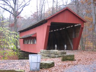
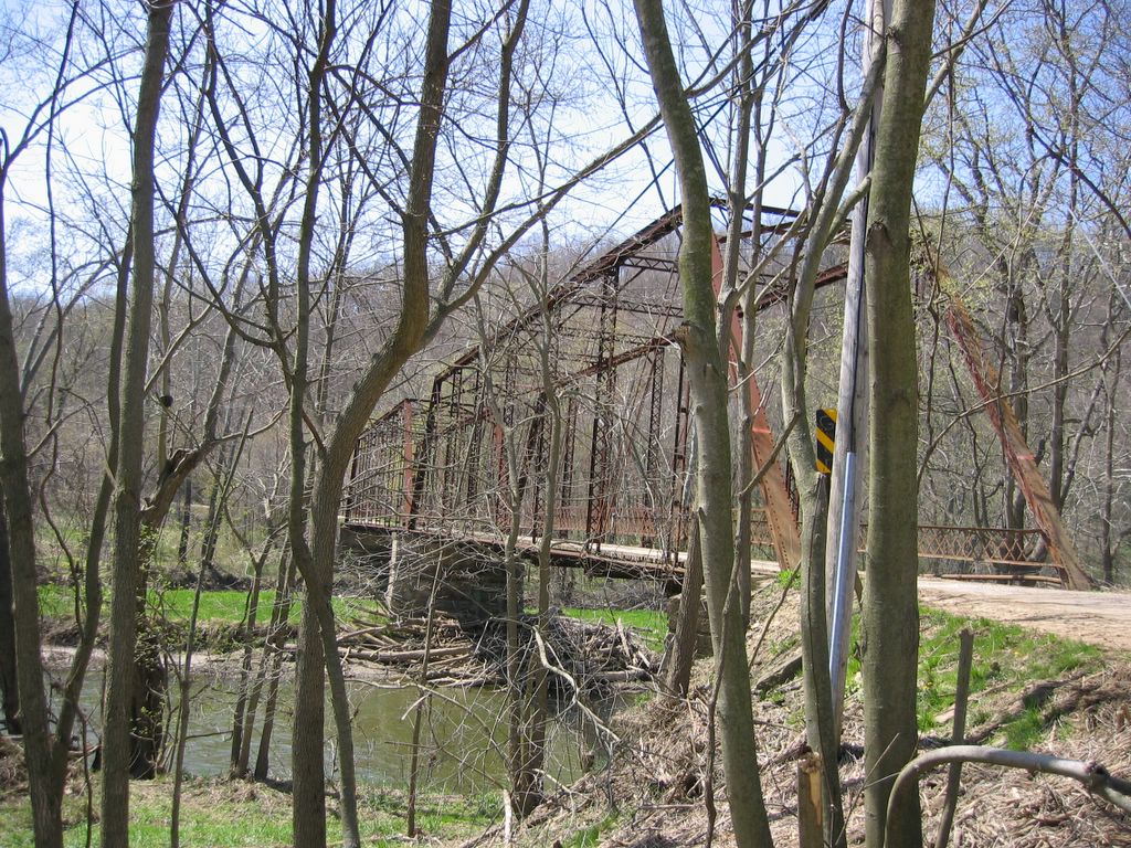
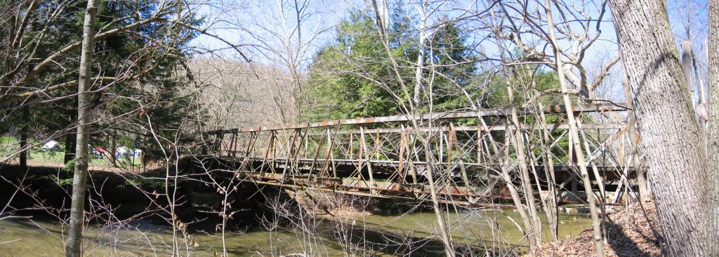
Many people limit themselves to covered bridges when thinking of historic bridges. The one in the picture is a nice example. It was restored and moved to a park in Fairfield County when replaced with a modern bridge at its original location. There were once thousands of these bridges in Ohio. They were largely replaced first by iron then steel truss bridges beginning in the second half of the 19 th Century. Perhaps some people resent metal bridges because they displaced covered bridges. The metal truss bridges were themselves mostly replaced by continuous steel or prestressed concrete bridges, which are most kindly described as "functional" in appearance.

The CB bridge is vulnerable to fire and rot and since it floats is easily "removed" by floods. There are only about 100 old CB left in Ohio and most of these are closed to traffic. I have a link to the covered bridge locations in Ohio on my Website.

Personally, I prefer the asthetics of the metal truss bridge.

Debate in Knox County.

Check out this link to read about the debate in Knox County over which bridge to spare!

http://www.knoxpages.com/Default.asp?NewsID=3054 Posted by Hello

With limited funds the county may have to choose between the Hunter Road Bridge and the Old US 62 bridge. That's my photo of the Hunter Road Bridge in the article.

Saturday, April 16, 2005

Knox County Road Trip # 1

The Hunter Road Bridge, Knox Co. Posted by Hello


This bridge in Knox County just made the National Registry. Built in 1904 it is a very nice example of a 2-span Pratt Through Truss. It seems that most of the surviving bridges like this are way out in the country on a gravel road! Nice ride on a warm spring day.

Friday, April 15, 2005

Morrow County Road Trip #1


Morrow County Bridge Posted by Hello

I began my search of Morrow County last Sunday around the town of Marengo. There appear to be a lot of old small Pratt Pony Truss bridges in this region. This one is a particularly good example. Most were located on loose gravel roads - not the best surface for a streetbike!

Monday, April 11, 2005

Another Bridge is Gone!

Last Photo of Stockwell Road Bridge Posted by Hello


I checked out the Stockwell bridge site on Sunday to note the "progress" with the new construction and found only the abutments of the Stockwell Road Bridge remain. Don't know if they dismantled the bridge and saved the components or just tore it down.

Saturday, April 09, 2005

Licking County Road Trip #2


Falling Rock Camp Bridge Posted by Hello

Today I traveled to the remaining 5 bridges in Licking County that I hadn't visited before. Of these 2 were historically significant. The others were replacement Warren Welded Pony Truss bridges (the county must have got a quantity price on these!).

The pictured bridge was the day's reward! It is a very rare Post Truss Bridge dating to 1872. It connects Rocky Fork Road to a Boy Scout Camp but is now closed to traffic.

Thursday, April 07, 2005

Licking County Road Trip # 1


Licking County Bridges Posted by Hello

Wednesday was a beautiful spring day here in central Ohio so I went bridge hunting. I entered the coordinates of the 14 Licking County bridges I have not yet visited into my GPS and took off on my motorcycle to see them. This was my first trip on my bike since I changed the chain gear ratio so it was also a test ride to see if I liked it.

Well I was off to a bad start. The first bridge was gone - replaced by a concrete culvert. This was not a good sign about the accuracy of the data I had retrieved from the Ohio DOT! I went on to the next bridge. It was there but appeared not to the original bridge but one considerably newer than the reported build date of 1900 . It was not the even the same design as reported so undoubtedly had been replaced.

I made it to a total of 9 bridge sites before calling it a day. The overall results: 2 were gone and the 7 others were replaced. All replacement bridges were similar Warren welded pony truss bridges one of which is shown in the picture. A very disappointing day. I hope I'm luckier with the other 5 bridges. Well at least the bike ran well. I think I like the new gear ratio

Tuesday, April 05, 2005

Visiting the Bridges


A GPS Screen. Posted by Hello

I have found that the easiest way to find these old bridges is with a GPS. The latitude / longitude coordinates of many historic bridges may be found on the Internet. Check out my website in LINKS for a list of old metal bridges in Ohio. There you will also find a link to the coordinates of all Ohio covered bridges.

My procedure is to enter a list of bridge coordinates into my GPS (CoPilot Pocket PC ver 5) then have the GPS sort the list to optimize the travel order. A simpler GPS would just require a little more planning and the need to enter coordinates while out on the road. It's still best to plot bridge locations using mapping software to select the groups of bridges that you want to visit on a particular trip. I like Delorme Topo USA map software as it shows virtually all the creeks and rivers unlike MS Streets and Trips.

I hate dealing with paper maps when traveling as I usually ride my motorcycle. A GPS is more than just a convenience as otherwise I would have to stop a lot to check a map. Ever tried to unfold and study a map at forty mph while operating a motorcycle?

The down side of a GPS is that it's so helpful you tend not to think about navigation. If it ever broke on a trip I might have trouble getting home!